


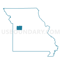
Simpson Voting District, Johnson County, Missouri
About
Outline

Summary
| Unique Area Identifier | 608868 |
| Name | Simpson Voting District |
| County | Johnson County |
| State | Missouri |
| Area (square miles) | 45.07 |
| Land Area (square miles) | 44.92 |
| Water Area (square miles) | 0.15 |
| % of Land Area | 99.66 |
| % of Water Area | 0.34 |
| Latitude of the Internal Point | 38.88193620 |
| Longtitude of the Internal Point | -93.65681540 |
Maps


Graphs
Select a template below for downloading or customizing gragh for Simpson Voting District, Johnson County, Missouri


Neighbors
Neighoring Voting District (by Name) Neighboring Voting District on the Map
- Aullville Voting District, Lafayette County, MO
- Concordia Voting District, Lafayette County, MO
- Hazel Hill Voting District, Johnson County, MO
- Lowland Voting District, Johnson County, MO
- Montserrat Voting District, Johnson County, MO
- Warrensburg Northeast Voting District, Johnson County, MO
Top 10 Neighboring County Subdivision (by Population) Neighboring County Subdivision on the Map
- Warrensburg township, Johnson County, MO (23,218)
- Freedom township, Lafayette County, MO (3,546)
- Montserrat township, Johnson County, MO (1,861)
- Hazel Hill township, Johnson County, MO (1,824)
- Grover township, Johnson County, MO (656)
- Simpson township, Johnson County, MO (583)
Top 10 Neighboring Unified School District (by Population) Neighboring Unified School District on the Map
- Warrensburg R-VI School District, MO (25,863)
- Knob Noster R-VIII School District, MO (8,419)
- Lafayette County C-1 School District, MO (6,585)
- Concordia School District, MO (3,799)
- Johnson County R-VII School District, MO (3,630)
Top 10 Neighboring State Legislative District Lower Chamber (by Population) Neighboring State Legislative District Lower Chamber on the Map
- State House District 122, MO (40,384)
- State House District 121, MO (37,199)
- State House District 26, MO (33,935)
Top 10 Neighboring State Legislative District Upper Chamber (by Population) Neighboring State Legislative District Upper Chamber on the Map
Top 10 Neighboring 111th Congressional District (by Population) Neighboring 111th Congressional District on the Map
Top 10 Neighboring Census Tract (by Population) Neighboring Census Tract on the Map
- Census Tract 9603, Johnson County, MO (8,910)
- Census Tract 9601, Johnson County, MO (8,677)
- Census Tract 905, Lafayette County, MO (3,849)